Update on 9/14 at 10:05 a.m.
The eye of Hurricane Florence made official landfall on Wrightsville Beach this morning. What can we expect from here?
Right now, the National Hurricane Center is listing the system as a Category 1 storm with winds of 80 mph. Soon, that might be downgraded to Tropical Storm status.
The wind impacts have not been as wild as the Category 4 status of the storm earlier this week would have brought. However, several reporting stations in eastern North Carolina have reported wind gust in excess of 100 mph. At the Wilmington Airport the peak gust was 105 mph. That is second only to Hurricane Donna in 1960.
From here, the system is moving slowly west-southwest on a track into South Carolina. For a couple of hours it might actually come back over the waters off shore of the Little River Inlet area and North Myrtle Beach. I do not expect it will regain much strength during this time, but it won’t lose any either.
From here on it becomes a duration and water event. The winds will become onshore winds across eastern North Carolina and those will bring in more water along the shore and make the water flowing in rivers, creeks and tributaries stop or flow backwards. The flooding will be epic. The rain will continue fall on saturated and flooded areas.
As I am writing, there are nearly 20 flood stage problems from Virginia, North Carolina, and South Carolina, and 14 major flood stage problems. There will be many more over the next 48 hours.
Updated on 9/13 at 10:23 a.m.
What is the latest update on Hurricane Florence?
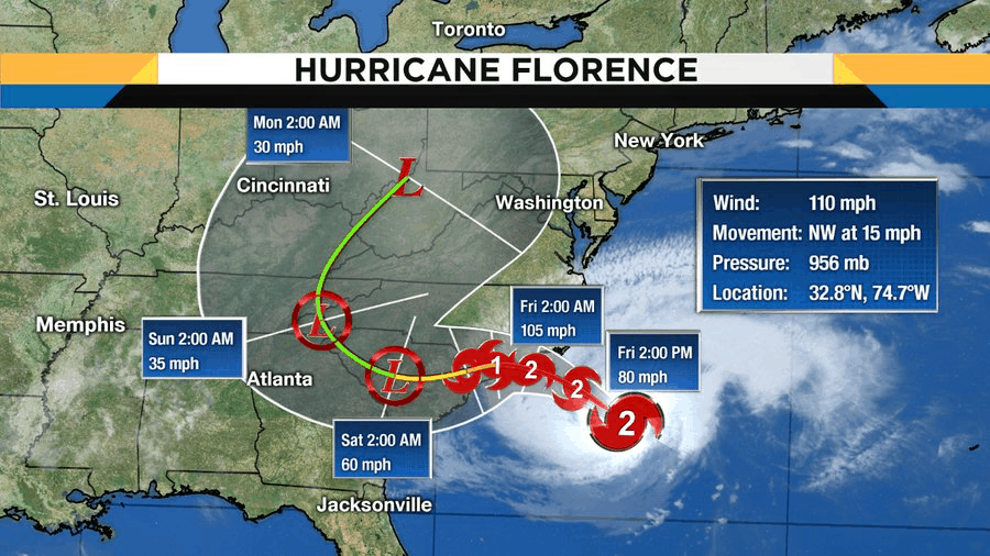
The latest location of Hurricane Florence is .275 kilometers east-southeast of Wilmington, N.C. with maximum sustained winds of 110 miles per hour. Winds of that speed make Florence a strong Category 2 Hurricane. At this point, I don’t expect the storm to get much stronger. It looks like it will linger just off the coast of North Carolina, or maybe slip the eye on shore sometime this evening around 8 p.m. or overnight into Friday morning.
Once the eye makes landfall it will drift and move slowly west-southwest over the state line back into South Carolina. Look for conditions along the coast to really fall apart rapidly this afternoon as the outer band of the Florence moves on shore. These bands will produce torrential rain, and possibly tornadoes, with no notice.
The storm surge along the coast will be life threatening. Any residents that did not evacuate should rush their final preparations and take shelter for a long weekend.
A Tornado Watch has now been issued for the following counties in North Carolina: Beaufort, Carteret, Craven, Dare, Duplin, Greene, Hyde, Jones, Lenoir, Martin, Onslow, Pamlico, Pitt, Tyrrell, and Washington.
Rainfall totals are expected to be in excess of 20 inches in parts of eastern North Carolina in the path of Florence. Please remember that while most of the information you will read, hear, and see, will be about the eye of the storm, a hurricane is not a point! This is a huge, wide, massive, slow-moving system. Take care to not be outside, limit your exposure to the elements, and be patient.
Updated on 9/12 at 9:27 a.m.
The updated path of Hurricane Florence is moving farther south. What does this mean for North Carolina?
If the eye moves south, that will spare North Carolina from a lot of the hurricane force winds, but the tropical storm force winds still extend out about 150 miles. The point I keep trying to make is that the hurricane is not a dot. It’s a big nasty storm that will have far-reaching impacts that people don’t expect, especially if they let their guard down.
When your expectations are changed by the path, you can really get in trouble. Pay attention to the cone and know that impacts will still be far-reaching away from that cone. Wilmington is still ground zero, so impacts to North Carolina are still huge.
While parts of North Carolina are still rebuilding from the damage of Hurricane Matthew, Hurricane Florence is set to make landfall this week with potential “life-threatening” damage across the state. Evacuations are underway along the coast and numerous school systems and universities have already announced closures.
I recently spoke with my dad, chief meteorologist at WKMG News 6, the CBS affiliate in Orlando, Florida, about how this storm compares to previous severe weather in North Carolina and what you can expect in the coming days.
Nearly two years ago, Hurricane Matthew devastated eastern North Carolina. How does Hurricane Florence compare to that storm as far as size, speed, intensity, and track?
On satellite the two hurricanes are both impressive. Matthew was a Category 5 at its apex. The big difference in the storms will be the strength at landfall, angle of landfall, and finally rainfall totals after landfall. Florence is set to make landfall as a much stronger system. It will be a major hurricane, Category 3 or higher, at landfall. By comparison, Hurricane Matthew had been a Category 5 in the open waters of the Atlantic, had weakened to a Category 1 by the time it made landfall in South Carolina, and then became a tropical storm and then a depression as it produced the rain and flood waters that rocked North Carolina. Florence will be a head-on collision from the east-southeast, not a glancing blow from the south. This will produce tremendous wind damage, storm surge, tornadoes and high winds.
Please don’t make the mistake of thinking you survived Matthew so you can survive Florence the same way. The strength and angle of landfall will produce dramatically different results. The rain after landfall will be life-threatening. After Florence strikes the coast, the system will stall over North Carolina. Heavy rain will continue off and on throughout the weekend. Model estimates are for anywhere from 15 to 30 inches of rain to fall over the three-day period.
For now, it’s predicted the storm will make landfall in the area of Wilmington, NC. When is the last time the North Carolina coast took a direct hit from a hurricane?
Oh, North Carolina has a long history of direct hits from hurricanes. Most people elsewhere might think of hurricanes as a Florida, Texas, New Orleans kind of problem. But the Carolinas are their own hurricane alley.
If you combine the coast from Cape Hatteras down to Georgetown, S.C., the shoreline has a historical 50 percent chance of a tropical system every year. Some of the more famous North Carolina hurricanes include Hazel, which directly hit near Wilmington back in 1954, and Hugo, which made landfall near Charleston, S.C. but was still a Category 1 hurricane as it ripped into Charlotte. There was also Fran in 1996 and Floyd in 1999.
It could be a category 4 at landfall – that’s not very common is it?
Most hurricanes are not major hurricanes. Remember to be considered “major,” the storm has to be Category 3 or higher. That means the winds have to be 111 miles per hour or greater. Since 1851, North Carolina has suffered a direct hit by 55 hurricanes. Only seven of those were major hurricanes. So far, there has never been a recorded Category 5 landfall in North Carolina.
What factors should people consider about their homes and about the area where they live when deciding whether or not to evacuate?
I believe the main factor is can you survive the impact of the storm in the first 12 hours, then survive alone there for three days after? By survive the first 12 hours I mean: Is your house safe from falling trees, rising water, and structural failure? In essence, can it withstand the impacts of the wind that is coming, or will the roof come off?
Most people picture the waves and storm surge when they think of being in danger from the hurricane. But the falling trees — what the insurance industry will refer to as canopy damage — will be epic, widespread, and deadly in this storm. If your house has grand old oak trees that hang over it, you can not trust them to withstand this type of storm without falling.
Also remember that most people who die in hurricanes away from the coast die from freshwater flooding. The hills and mountains will not absorb the kind of rain that a tropical system brings. Rising rivers, creeks, streams, ponds, street flooding, and backed up drains will all become problems this weekend. Please consider that in times of crisis, when the storm is at its worst, emergency management, police, and firemen can not come to you.
You need to understand that if you do not seek proper shelter, you may end up on your own in a bad situation. You also need to be ready to be without any government rescue or aid for up to at least three days. So consider that if you have elderly parents, grandparents, pets, or any other special needs situation.
Let’s talk about the potential impacts across the state from the coastal plains, through the Piedmont and to the mountains. What may happen and what do residents need to know?
The coastal plains will suffer major impacts from wind, storm surge on the coast, and heavy rain. The storm surge is projected to be as high as 12 feet near the center of the storm. Understand that the hurricane is not a single point. Storm surge totals for you may be higher than some estimates. And the surge will not only be near the eye wall. Up and down the coast over the entire state the water will rush in. The winds will be at their worst near the eye of the storm and the surrounding eye wall, but even as far as 150 miles from the center, the winds will still be Tropical Storm force.
If Florence remains on its projected path, the areas in the Piedmont will have a long night Thursday into Friday morning. It’s near the Raleigh area that the center may drill into the state. Again I repeat, a hurricane is NOT a point — it is not out of the question that the Raleigh-Durham area could have Category 1 or higher winds.
Closer to Charlotte, the winds would probably not be as strong, but keep in mind that is only if this storm verifies and stays on the current projected path. Any deviation from that track could put any spot in central and eastern North Carolina in the higher winds.
Outside of the wind, my major fear for all of you is the water. The storm surge to be sure, but even more so the rain totals. Florence will make landfall and then stall and rain heavy totals over the weekend. I am hesitant to say this — I don’t want to be inflammatory or over dramatic — but the flooding could look biblical to the residents there.
If you were there for the floods of Hurricane Floyd in 1999, know that all of that was caused by about 17 to 20 inches of rain. Florence has the potential to produce up to 30 inches of rain over three days. The increase in population, the development that has been done, and the addition of paved areas all lead me to fear catastrophic flooding.
I cannot say it enough, the hurricane is not a point. The impacts will be widespread. The heavy rain will pour over most of the state. Lighter totals will be seen as far west as Asheville, but even there, some areas could see totals past several inches.
When do you predict the storm and all of its effects – the wind and rain – will be out of North Carolina?
I believe you will see a slowdown in winds every passing day. But the rain and breezy conditions should hang on until at least Monday. And the clean up will be weeks and months in the making.
After the hurricane passes, school district leaders around the state will begin assessing damage and making decisions about opening. North Carolina predominantly has county-wide districts – some that are very large and that cover a mix of rural and urban areas. What kinds of challenges does that create when determining whether to open?
I believe the process of reopening will be a slow one. The time it takes to assess all the damage will be days. I believe the schools in a large part of North Carolina will not be able to open most of next week, if not longer. There will be lots of considerations. Power will be hard to come by. Transportation will be an issue with roads blocked by trees, water, and debris. You have to consider the schools’ ability to function. If you don’t have power at the schools, you can’t open. You will have families, employees, that have no way to prepare for work, no hot water, and no way to prep meals.
In large counties where damage may vary greatly from one area to another, keep in mind that it is still a county-wide decision on when to open. If roads are impassable in one section that still likely means the entire county will remain closed.
What can parents and teachers say to young people if they are feeling anxious about Hurricane Florence?
This is always kind of a tricky situation. You don’t want to scare them, but they do need to understand what is going on. And if you are freaked out and wound tight, they will sense it. So, I would say let them know you are aware and that you have planned for this to happen. Try to make it as much of an adventure as you possibly can. And keep the schedule as normal as you can. Of course this is all easy for me to say. During every hurricane my family has gone through, I am always at work, and your mom was the one to take care of you and your sisters when you were younger. So, I might be the wrong person to ask.
And finally, what websites or resources do you recommend people use for accurate, up-to-date information about the storm?
Good information is not hard to come by, but bad information is everywhere! One of the downsides of social media is the chance for every single person with access to be able to not really be a meteorologist but play one on the internet.
For the best location and path of the storm, the source is the National Hurricane Center. You can get the update at this website. Local impacts for your area will be well covered by the National Weather Service office in your area. Start here.
As a broadcast meteorologist, I would encourage you to go back to your favorite local TV station for updates. If a hurricane is near, you can expect the TV to be in continuous coverage of the event. Turn to a trusted, experienced meteorologist in your town. Try to find one who has been there for years and has the AMS CBM credential by his or her name. Watch that person and follow them on Facebook and Twitter. We are all social media active and there for you.
In conclusion
Have a plan. Get your water and nonperishable foods. Get ready. And know that your plan is not perfect. As former heavyweight champ Mike Tyson used to say, “Everybody has a plan until they get punched in the mouth.” I believe planning for a hurricane is like that. You have a plan, and then the hurricane punches you. So, the plan has to change. That is when you have to have “The Gumby Plan.” Gumby is flexible. Your plan has to be the same. Make a plan, but have options. Be flexible.
Most of the people who die in a hurricane were doing something they were not supposed to do. Do not be one of those people. Do not become a statistic.
Act now.
See you when it’s over.


Recommended reading