
Hurricane Erin: Updates on storm, preparation, and closures of schools and community colleges
Editor’s note: This article will be updated twice a day — around 11 a.m. and 5 p.m. — or more frequently as needed. School district and community college closures are determined based on the latest information found on district and community college websites, as well as their Twitter and Facebook accounts when applicable. Are we missing something? Let us know by emailing alindenberg@ednc.org.
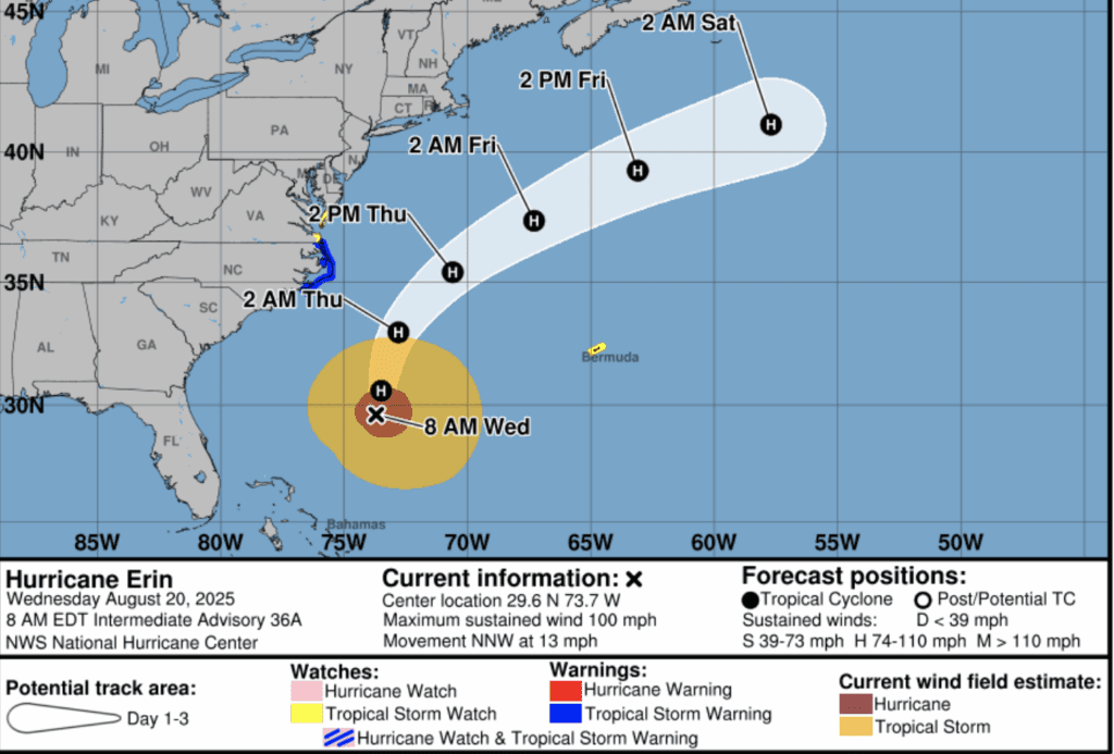
On Tuesday, Aug. 19, Gov. Josh Stein declared a State of Emergency as North Carolina prepares for Hurricane Erin’s impact on the coast, which is expected to start Wednesday evening and last through Thursday.
“While Hurricane Erin is expected to remain offshore, North Carolinians along the coast must remain vigilant as coastal flooding and life-threatening rip currents continue to impact the region,” Stein said in a press release. “Our State Emergency Response Team remains ready to quickly respond to any needs and keep coastal residents and visitors safe.”
 Sign up for the EdDaily to start each weekday with the top education news.
During a media advisory on Wednesday morning, Stein said the category two storm is currently forecast to remain offshore. Director of Emergency Management Will Ray said the system is expected to fluctuate in strength and potentially gain speed as it moves away from North Carolina’s coast.
However, Ray said “Erin remains a dangerous hurricane” and “a tropical storm warning is now in effect from Beaufort Inlet north to Duck and a storm surge warning is now in effect from Cape Lookout to Duck.”
Local States of Emergency have been declared in Currituck County, Dare County, and Hyde County, Stein said, and mandatory evacuations are in place for both visitors and residents of Ocracoke and Hatteras islands. There is a state-operated shelter available for North Carolinians who have evacuated from the coast in Warrenton, located at 113 Wilcox Street. Pets are allowed at this shelter, Stein and Ray said.
Forecasts anticipate that Hurricane Erin will cause extensive beach erosion with waves of 15 to 20 feet; coastal flooding that may impact roads, structures, and vehicles; and life-threatening rip currents throughout the week. Tropical storm force winds will likely reach the coast, especially the Outer Banks, late Wednesday and Thursday.
Press release from the Office of the Governor
Stein and Ray urged North Carolina residents along the coast to prepare for the storm now, by:
Being informed: Follow reputable sources of information like the National Weather Service, local media, and your local emergency management agency. Stein specifically warned residents to avoid getting up-to-date information from social media.
Having a disaster kit: If you are evacuating, take your disaster kit with you, along with your go-bag of important documents, cash, prescriptions, phone chargers, and insurance policies. If you are staying home, think of what you might need for three-to-five days without power after a storm, like enough food, water, and supplies like a flashlight, radio, and fresh batteries.
Having a plan: If you live in or are visiting potentially impacted areas, anticipate your evacuation route. Visit KnowYourZone.NC.Gov for more information. Make a plan with how to connect with your family after the storm — writing their numbers down on paper if you don’t have them memorized — and take photos of whatever you own that is valuable in case it gets destroyed.
Not driving through flood waters: Stein said the state has seen too many cases of lives lost due to driving into flooded roadways. He said you cannot tell the speed or depth of flood water from inside of your vehicle, and should turn around. For the most up-to-date roadway information, visit DriveNC.Gov.
“I want to emphasize the importance of taking this storm seriously, because it’s a serious storm and conditions can deteriorate quickly,” Stein said. “Please take these steps to ensure your safety.”
For more information from the State Emergency Response Team, visit ReadyNC.Gov/Erin.
You can also find more tips on how to be prepared during a hurricane here.
Now, here’s a look at updates from local districts and community colleges impacted by Hurricane Erin.
School district closures and delays
Superintendent Melanie Shaver in Hyde County reminds us that for the third year in a row the first month of school has been interrupted by a storm. Stay safe.
Hyde County Schools has pushed back their opening date (at this point) for Ocracoke School until Tuesday, Aug. 26.
Dare County Schools shared that the Dare Early College will be in person on the COA-Dare Campus on Friday, Aug. 22 and will not be having an early release day. Hatteras Island Early College students will attend remotely.
Schools north of the Oregon Inlet will have an optional workday for all staff on Friday, Aug. 22, except Dare Early College. Staff members should confirm their work plans with their principal or immediate supervisor. Athletic games and practices will resume as scheduled. The first day of school will be Monday, Aug. 25.
Cape Hatteras Elementary and Secondary schools will remain closed on Friday, Aug. 22.
The district will continue to communicate with Dare County officials on the condition of roads and flooding and share any updates over the weekend as they have a clearer understanding of the storm’s impacts.
Tyrell County Schools has rescheduled the Tyrrell Elementary School Open House to Friday, Aug. 22, from 4:30 p.m. to 6:30 p.m.
Community college closures and delays
College of The Albemarle will remain closed for students and employees on Thursday, Aug. 21. This closure applies to all campuses — Elizabeth City, Currituck, Dare, and Edenton-Chowan.
Although facilities are closed, all classes scheduled to meet on Thursday will take place online (this includes both in-person and online courses).
Carteret Community College will remain open and operate on a regular schedule on Aug. 20 and 21.
In a Facebook post, the college said on Wednesday afternoon that: “If you live in an area more heavily impacted by the storm and do not feel safe or comfortable traveling to campus, please contact your instructors and/or supervisors so that accommodations can be made.”
Are we missing something? Let us know by emailing alindenberg@ednc.org.